Revolutionizing Surveying and Building Industry:
The Advantages of Skynetvideo’s Drone Photogrammetry and Aerial Services
In the past, surveying and building professionals faced numerous challenges in accurately capturing data, mapping terrains, and visualizing construction projects. However, with advancements in technology, specifically in the field of drone photogrammetry and aerial services, companies like Skynetvideo have emerged to offer innovative solutions to these industries. Let’s explore the advantages of Skynetvideo’s services and their significant impact on the surveying and building sectors.
1. Enhanced Data Collection Efficiency:
One of the most significant advantages of using Skynetvideo’s drone services is the unparalleled efficiency in data collection. Traditional surveying methods often required manual measurements and ground-based equipment, which could be time-consuming and labor-intensive. However, with drones equipped with high-resolution cameras and LiDAR sensors, surveyors can now capture vast amounts of data from the air in a fraction of the time. This efficiency translates to quicker project turnaround times and cost savings for the clients.
Example: Skynetvideo was contracted to survey a large construction site for a new highway project. Using drones, they completed the survey in just a few days, whereas conventional methods would have taken several weeks. The accurate and rapid data collection allowed the construction team to commence work earlier than expected, resulting in significant cost savings.
2. Improved Accuracy and Precision:
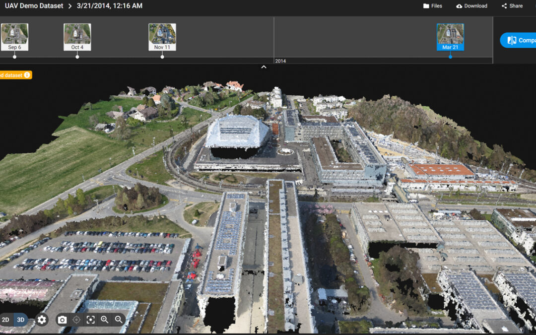
Drone photogrammetry and LiDAR technology offer higher accuracy and precision in data capture compared to traditional methods. The data obtained from aerial surveys can be processed using specialized software to create detailed 3D models, contour maps, and orthomosaic images. These outputs provide surveyors and architects with a comprehensive view of the terrain and structures, minimizing the chances of errors and facilitating better decision-making.
Example: Skynetvideo was hired by a real estate developer to conduct a topographic survey for a new residential project. By utilizing drone photogrammetry, they achieved sub-centimeter accuracy in their elevation models. The precise data helped the architect design the buildings more effectively, optimizing space utilization and avoiding potential construction issues.
3. Safety and Risk Mitigation:
In many cases, surveying and inspecting difficult terrains or tall structures could pose safety risks to human surveyors. Drones eliminate this danger by accessing hazardous areas without putting any personnel in harm’s way. By using Skynetvideo’s services, companies can ensure a safer work environment while obtaining essential data for their projects.
Example: Skynetvideo assisted a utility company in inspecting their power transmission towers. Rather than sending workers to climb each tower, drones were deployed to capture high-resolution images and thermal data. This approach identified potential faults and hotspots, allowing the company to conduct timely maintenance and prevent power outages.
4. Cost-Effectiveness:
Employing drones for surveying and aerial services often proves to be cost-effective in the long run. With faster data collection, reduced labor costs, and improved project management, clients can experience a higher return on investment. Additionally, the data obtained through drone surveys can lead to optimized resource allocation and streamlined construction processes, further enhancing cost efficiency.
Example: A mining company engaged Skynetvideo to survey their vast mining site. The drone survey allowed them to accurately assess the available resources and plan their excavation activities more efficiently. The optimized mining operations resulted in considerable cost savings and increased productivity.
5. Progress Monitoring and Documentation:
For construction projects that span over extended periods, regular progress monitoring is crucial. Skynetvideo’s drone services provide a consistent and reliable means of documenting project developments, allowing stakeholders to track progress and address any deviations from the initial plans promptly.
Example: Skynetvideo was contracted by a government agency to monitor the construction of a new bridge. Weekly drone surveys enabled the project managers to compare the actual progress with the timeline, facilitating better coordination between teams and ensuring the project stayed on track.
In conclusion, Skynetvideo’s drone photogrammetry and aerial services have revolutionized the surveying and building industries by offering enhanced efficiency, accuracy, safety, cost-effectiveness, and progress monitoring. These advantages translate into more streamlined and successful projects for various sectors, ranging from construction and infrastructure development to environmental monitoring and resource management. With technology continuing to advance, the role of drone services in these industries is only set to grow, empowering professionals to reach new heights in their endeavors.
Streamlining Building Worksite Management with Drone Photogrammetry Services:
Tracking Weekly Material Volumes and Pile Movements
In addition to the broader advantages mentioned in the previous article, Skynetvideo’s drone photogrammetry services offer unique benefits to building worksite management. By leveraging the power of drones equipped with advanced cameras and sensors, construction companies can efficiently track and manage weekly material volumes, especially for materials like building sand and conglomerate piles. Let’s explore how Skynetvideo’s drone photogrammetry services facilitate worksite management, ensuring optimal resource allocation and construction progress.
1. Accurate Material Volume Calculation:
Traditional methods of measuring material volumes on construction sites often involve manual measurements or the use of heavy machinery, which can be time-consuming and may lead to errors. With drone photogrammetry, Skynetvideo can obtain high-resolution aerial imagery of the worksite, including building sand and conglomerate piles. This data is then processed using specialized software, generating precise 3D models and volumetric calculations.
Example: Skynetvideo was contracted by a large construction firm for their high-rise building project. By conducting weekly drone surveys, the company accurately measured the volume of building sand and conglomerate piles. The precise data allowed the project managers to order the right amount of materials, reducing waste and saving costs.
2. Efficient Progress Monitoring:
Monitoring the movement of materials on a construction site is critical to ensuring smooth project execution. Drones provide an efficient way to track changes in the volume and location of building sand, conglomerate piles, and other construction materials over time. The ability to conduct regular aerial surveys facilitates weekly progress reports and identifies any issues or delays promptly.
Example: Skynetvideo’s drone photogrammetry services were employed by a construction company building a large infrastructure project. By comparing weekly surveys, the project management team identified that certain areas received inadequate materials, causing a bottleneck in construction. Adjustments were made promptly, preventing further delays.
3. Real-Time Data for Decision Making:
With drone photogrammetry, construction managers can access real-time data on material volumes and pile movements. This data empowers them to make informed decisions quickly, ensuring that construction resources are optimally allocated. The ability to react promptly to changes in material requirements and worksite conditions enhances overall project efficiency.
Example: Skynetvideo provided drone services to a bridge construction project. During a particularly rainy week, the survey revealed that certain areas of the site experienced material erosion. The construction team addressed the issue immediately, preventing potential safety hazards and project setbacks.
4. Enhanced Communication and Collaboration:
Drone photogrammetry data provides a visual representation of the worksite, making it easier for different teams and stakeholders to understand the progress and material movement. The visual documentation enables clearer communication and collaboration among architects, engineers, construction crews, and clients.
Example: Skynetvideo’s drone surveys were instrumental in a commercial development project. By sharing detailed aerial images and 3D models with all parties involved, including investors and regulatory authorities, the construction company fostered better communication and alignment on project milestones.
5. Environmental Impact Assessment:
Beyond construction efficiency, drone photogrammetry also aids in environmental impact assessment. By monitoring material movement, companies can analyze potential ecological consequences and implement mitigation measures. This demonstrates a commitment to sustainable practices and compliance with environmental regulations.
Example: Skynetvideo’s drone surveys were utilized by a company constructing a solar farm. The surveys allowed them to monitor the excavation and movement of conglomerate piles near sensitive ecosystems. This information facilitated the implementation of measures to protect local flora and fauna.
Skynetvideo’s drone photogrammetry services offer indispensable advantages for building worksite management. By tracking weekly material volumes and pile movements accurately, construction companies can streamline resource allocation, enhance project efficiency, and improve communication among stakeholders. The real-time data obtained through drone surveys enables informed decision-making and proactive problem-solving, resulting in successful and environmentally responsible construction projects. Embracing drone technology in worksite management ensures that the construction industry continues to progress into the future with increased precision and sustainability.